Searching for travel routes
To find a public transport or car route between any two points on the map, use the Directions block on the Search tab. A route is generated with regard of possible transfers, pedestrian crossings, and prohibitions on U-turns and other turns.
To search for a route:
- Specify the starting point.
- Specify the destination point.
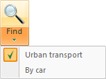
- Click the Search button. To select the type of transportation for the route, click the dropdown menu arrow of the Search button.
The plotted route is highlighted in purple on the map. The cards of travel options are displayed in the Transport directory.

Selection of points to search for travel options
Select the points using the following methods:
Method 1
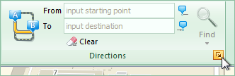
Specify the names and addresses of the objects to be connected with the route line in the From and To fields of the Directions block. These objects can be: stops, houses, streets, districts, or microdistricts. After entering the first few letters of the name, suggestions appear (a dropdown menu), where you can select the desired object.

Method 2
Click any object or any point on the map and use the links of the resulting information card to search for travel options from here — to here:
- from here — to select the starting point;
- to here — to select the destination.

Method 3
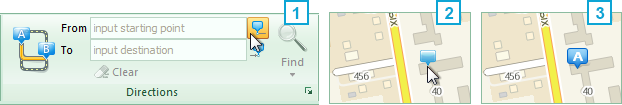
Click the  symbol to select the From field or the
  to select the To field, then click the desired place on the map. The name of the object specified will then appear in the selected field.
Method 4
Use the corresponding points on the map context menu:
- Directions from here — to select the starting point;
- Directions to here — to select the destination.
To select additional points of the route, use the map's context menu (Add destination) or the Directions dialog window.
In the Directions dialog window, you can also set additional options to plot a route:
- specify type of transport;
- add/remove intermediate points of the route;
- change the sequence of specified points (up/down arrows); and
- plot the return route.
Changing the route
To change the route, simply guide the pointer to the desired location and, while holding the left mouse button, drag it to another place on the map.

Route preferences
Preferences can be added to an automobile route. Guide the mouse pointer to any part of the route, thereby displaying a white circle-shaped marker, and, while holding the left mouse button, drag the marker to the place that you would like to pass on the route. The route will be automatically re-plotted after the preference is added.
